The Highs of Tacoronte
Vegetation Analysis
Our survey examined a stretch of approximately 20 metres, where a transition between Pine forest (Pinus canariensis) and Laurel (Laurus canariensis) was seen. The pine dominates above the thermophile brush on the NE of the island, before transitioning into heather with decreasing elevation, with a final change being seen in the appearance of more laurel in the Monte Verde. This change reflects variations in moisture, temperature, and disturbance within the Critical Zone.
The Impact of Water
At Tacoronte, pine trees intercept moisture from the trade winds, which moves downslope, feeding the laurel and soil below. This shows how vegetation actively shapes water movement in the Critical Zone.
FIRE
Following the August 2023 wildfire, reduced biodiversity can be seen within the pine forest. This means that fire-resistant P.canariensis dominates in the area. L.canariensis is seen lower down, in the areas unaffected by the fire, here there is very minimal pine. This indicates how disturbance and resilience can vary within the Critical Zone


Percentage Abundances
Site 1 (Pine Forest):
15% Bramble
30% Bracken
45% Leaf litter (pine needles)
7% Pine Trees
2% Lichen
1% Fungi (Hairy Curtain Crust)
Site 2 (Laurel Forest):
25% Canary laurel
74% Laurel saplings
1% Persea indica
Soil Analysis
We visited a site on the edge of the Pine Forest to analyse a soil profile.
This soil falls under the Andisol category indicated by the characteristic melanic epipedon, "fluffy" and friable texture, and dark colouration indicating high organic matter content. These features relate to key Critical Zone processes, such as the weathering of volcanic material and build-up of organic matter. The porous nature of andisols also allows for the regulation of water movement and storage within the Critical Zone.
We concluded that the parent material was aeolian volcanic ejecta formed from pyroclastic tephra. This emphasises how volcanics control soil formation within Tacoronte, influencing soil structure, nutrient availability, and thus what flora can be supported. These interactions between the soil and the climate illustrate how soils are key within the Critical Zone, linking the biosphere with the lithosphere and hydrosphere.


Soil Horizons
O Horizon
- 2 cm thick, mostly made of decomposing organic matter
A Horizon
- 40 cm thick as seen by clear overhanging due to a change in density of the roots holding the soil in place
B horizon
- 80 cm thick
- 2 m down there was a change to 2B with a change in parent material, shown by a color and density change
- There was also Scoria ejecta and Basaltic material present, with chunkier blocks of material
Southern Tenerife
Las Margaritas Banana Plantation
At Las Margaritas Banana Plantation, we examined how banana plants grow and are managed within a volcanic semi-arid environment. These characteristics reflect how agricultural productivity is ultimately shaped by the underlying soil and weathering conditions that define the Critical Zone. Key observations include:
- Shallow roots systems averaging ~45 cm, making growth strongly dependant on nutrient availability in weathered lava soils.
- Banana plants take around 11 months to flower and up to two years to fully mature.
- Bananas are hermaphroditic, meaning they possess both male and female productivity structures.


The Adaptations of Vegetation on the South of the Island
The vegetation surrounding the Las Margaritas Banana Plantation reflect the harsh conditions of the Critical Zone, with species adapted to thin soils, salinity (halophytes), and limited water availability (xerophytes). The Canary Island spurge stores water in its thick, fleshy stems, reducing its dependence on soil moisture during dry periods. The ice plant, as pictured, manages water stress through succulent leaves that retain moisture and tolerate salt accumulation, allowing it to establish on degraded soils where little else survives. The barbed wire plant has adapted to the conditions by losing its leaves entirely, which reduces transpiration to a minimum and directing what little resources available to survival.
These adaptations are a direct response to environmental conditions in the Critical Zone. Thin soils have limit rooting depth and nutrient availability, and high salinity makes water uptake difficult. This results in a plant community shaped by these pressures, thus the vegetation is a direct reflection of the area’s underlying geology, hydrology, and soils.
Volcanic Deposits and the Critical Zone
Observations of volcanic deposits demonstrate how surface processes influence the structure and evolution of the Critical Zone. Fall deposits consist of evenly distributed ash and fine tephra that weather into fine-grained soils over time. Surge deposits are characterised by shallow cross-bedding and very fine grain sizes. Pyroclastic flow deposits are poorly sorted, contain large pumice blocks, and fossilised gas tunnels. This helps distinguish them from lahars, which form from water remobilisation and carry more angular clasts.
Together, these deposits have influenced the drainage and land use of the area. Their varying grain size and porosity affects how water moves and infiltrates, and how readily nutrients become available as weathering progresses. This shapes the conditions under which soils will eventually develop.


Parque Rural de Anaga
At around 900 m in the northeast of Tenerife, we visited an endemic Laurisilva forest to carry out soil analysis. The forest floor was covered in needles and leaf litter, with volcanic soil beneath that was dark, loose, and strongly shaped by constant moisture from the cloud belt. We measured pH, EC, colour, and texture, noting how altitude, vegetation, and persistent cloud cover influence infiltration, organic matter build‑up, and overall soil development. This site clearly shows how climate and volcanic parent material interact to create a unique forest soil and environment within the Critical Zone.
The soil profile comprises a thin O horizon of fresh and partially decomposed organic material. This overlies a 50–70 cm melanic A horizon with very dark colour, low bulk density, and high SOM typical of andic soils formed from volcanic ash. Below this, the 2B horizon showed a weaker NaF reaction and a shift in parent material, while deeper layers consisted of stacked tephras from multiple eruptions, including palaeoandisols where former A horizons have been removed or buried. These layers record long‑term volcanic activity and landscape change, forming the geological foundation of the Critical Zone at this site.
Across the profile, the interactions between soil, vegetation, water, and volcanic rock are clear. The andic horizons regulate water storage and movement, supporting the moisture‑dependent Laurisilva vegetation. While the forest contributes litter, roots, and nutrient cycling causing the melanic epipedon. Simultaneously, cloud‑belt moisture drives leaching and weathering, and tephra layers preserve the island’s eruptive history. Together, these processes show how geology, hydrology, biology, and the atmosphere continuously shape and interact with one another within the Critical Zone.
Parque Nacional del Tiede
Whilst travelling towards the caldera, we stopped at several viewpoints such as Mirador de Ortuño and Chipeque where changes in vegetation with altitude were clear. At lower elevations the pine forest was more open, becoming denser upslope due to over‑successful afforestation, which has increased competition between trees. These vegetation patterns reflect how climate, soil moisture, and human activity shape the biological component of the Critical Zone. From these viewpoints we could also see the remnants of the 2023 Arafo‑Candelaria wildfire, a major disturbance driven by unusual westerly winds rather than the typical northeast trade winds. This event highlights how atmospheric conditions influence Critical Zone processes by altering fire behaviour, vegetation structure, and subsequent soil recovery. Normally, this area overlooks the sea of clouds formed when moist trade‑wind air rises, cools, and condenses, but Calima disrupted this process, showing how atmospheric dust events can temporarily alter the hydrological and climatic dynamics of the Critical Zone. Upon reaching the caldera (formed when the interior of the volcano collapses after major eruptions) we observed how the exposed walls reveal the volcanic materials underpinning soil formation across the landscape. The vegetation here reflects the interaction between volcanic parent material, limited water availability, and high‑elevation climate. Altogether, these observations show how geology, atmosphere, water, and vegetation interact continuously to shape the structure and processes of the Critical Zone in this specific part of Tenerife.


Merendero Dechio
At our final stop in Merendero Dechio we conducted a vegetation survey. Plants that were observed in this area were: pine tree (Pinus canariensis), lotus canpylocladus, chamaecytisus proliferus, and adenocarpus foliosus.
Vegetation survey
- 30% lotus campylocladus
- 40% dead pine
- 20% pine tree
- 7% tree lacerne
- 3 % sticky broom
A soil profile was also conducted at this site with insignificant O horizons observed and a Melanic epipedon in the A horizon. The soil properties were consistent with an Andisol.
The soil, water, vegetation, and volcanic rocks at this site all interact. The volcanic parent material provides the minerals that weather into the melanic, andic soils observed. While the cloud‑belt climate controls moisture availability, leaching, and organic matter accumulation. Vegetation influences the soil through litter inputs, root activity, and nutrient cycling, and in turn depends on the soil’s ability to store water and supply nutrients. Water movement through the porous tephra layers shapes horizon development and redistributes elements, while past eruptions and wildfire disturbances leave long-term marks on both soil structure and plant communities. Together, these components form a tightly interconnected system of feedbacks.
Punta del Hidalgo
On the northeastern coast of Tenerife, we examined a dry, exposed site located just above the Arid Zone. Terrain here was steep and rocky, with volcanic material visibly weathered and containing scattered, angular clasts. Vegetation was sparse, but consisted mostly of xerophytes, such as Lavandula buchii, Astydamia, cacti and succulents. Soil was alkaline, with pH values ranging between 8 and 8.5 across the profile. EC values were moderate, ranging between 60-140 µS, but decreasing with depth.
The soil was classified as a Vertisol, characterised by high clay content and desiccation cracks. Unlike younger soils such as Entisols, the profile has a more developed structure despite horizons being difficult to distinguish at the exposed surface. The clay-rich properties restrict drainage and influence root penetration. NaF tests gave negligible results indicating virtually no allophane present. The soil contains abundant angular rock fragments (2-80 cm), suggesting in situ weathering with little transport.
Geomorphologically, the site reflects an active and fragile Critical Zone system. The combination of steep slopes and episodic heavy rainfall promotes erosion and debris flows, with loose material easily remobilised downslope. Vegetation plays a key stabilising role, helping to bind the soil and reduce erosion risk. However, evidence suggests that human activity has reduced the extent of natural vegetation in this area, altering the system's natural balance. Overall, this site highlights how climate, topography, and human impact interact to control soil formation and landscape processes in a semi-arid coastal environment.

The relationship between Vegetation and Soil in Tenerife:
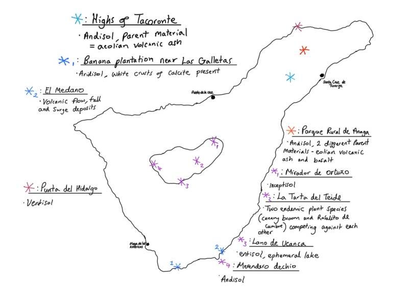
The map above shows the island of Tenerife with locations and key observations at each visited site. There are some general trends between the types of vegetation and soil orders in relation to their location and elevation on the island. Vegetation has adapted to a variety of different micro-climatic conditions, such as the halophytes that thrive in high salinity environments.
On the South of the Island where conditions are hotter and drier, the main soil order observed was an Aridosol. These are water-deprived meaning that plants in the region must adapt. An example is the barbed wire plant that has lost its leaves to reduce water loss to survive the extreme temperatures. Towards the North of the Island conditions are wetter and cloudier. The predominant soil order identified was Andisols which are very fertile soils. These can support vegetation such as the pine forests in The Highs of Tacoronte. A key adaptation of pine trees are their long needles that collect moisture from the clouds ("fog catchers") formed via the trade winds, therefore feeding vegetation at lower altitudes.